|
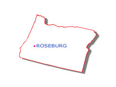
The corporate limits of Roseburg encompass roughly nine square miles, at an average elevation of 465 feet above sea
level. Click the city logo to the right for a map.
Four of the nicest things about Roseburg are its seasons. Winters are cool without much freezing and provide most of
the rainfall that brings blossom-filled springs. A warming trend begins in April and May, continuing into the summery
days of July and August. Fall weather is pleasant and crisp, producing brilliant leaf colors in late October.
The Hundred Valleys of the Umpqua have been compared geographically and climatologically with Italy and Southern
France. Extremes of heat and cold are rare. The summer humidity is low and snowfall is rare on the valley floor.
The normal growing season is 217 days. Roseburg enjoys one of the lowest average wind velocities in the United States.
Roseburg is 80 miles west of Diamond Lake. Diamond Lake is at the crest of the Cascades. The ocean shores are
approximately 70 miles to the west. Eugene is 70 miles north along Interstate 5 and Medford lies about 80 miles
to the south.
The South Umpqua River runs through town. It is noted for its summer small mouth bass and its winter steelhead
fisheries. The South Umpqua River joins the North Umpqua River approximately 12 miles west of town. There are
several scenic camping spots and points of interest close to Roseburg. Highway 138 leads to the east, adjacent
to the North Umpqua River. and will provide a scenic route to the Cascades and Diamond Lake.
The Umpqua Tribe of Indians occupied this area prior to the arrival of fur traders in the early 1800's The major
westward migration in the mid-1840's attracted Aaron Rose, born 1813 in Ulster County, New York. He and his wife
Sara came over the Applegate Trail.
Aaron and Sara Rose purchased a claim that was originally platted as the township of Deer Creek in 1851. He
envisioned a farming and commercial center flourishing here. A grist mill was opened that year on Deer Creek.
The following year a post office and school were established. In 1854 Aaron Rose offered the county three acres
of land and $1,000 for the county seat to be moved from Winchester. An election was held and three years later
the town was officially platted and renamed Roseburg.
Between 1865 and 1870, the area's population grew, largely due to an influx of soldiers engaged in the Rogue
River Indian Wars. The village of less than 500 residents became a terminal on the stage coach line that ran
between Sacramento and Portland in 1864. Roseburg was connected to the rest of the world by telegraph.
The first wood burning locomotive of the Oregon & California Railroad arrived in 1872. The coming of the
railroad attracted laborers, mechanics, engineers, conductors and others. In 1872 Roseburg was officially
incorporated. When incorporated the town consisted of five churches, twelve saloons, three hotels, seven
fraternal lodges, two grist mills, stables, harness shops, dry goods stores and a brewery. Aaron Rose's dreams
were becoming a reality.
From its founding to the present day, Douglas County's greatest wealth has been its forests. At the timber
industry's height, following World War II, there were 278 mills operating in the county. Most were cutting
timber, all were dependant on some of the largest old growth timber stands in the nation.
The fertile, lush valleys of the Umpqua have always yielded a wide variety of crops and nourished livestock,
making agriculture the area's second largest industry.
An increasing number of visitors are discovering the wealth of natural beauty and recreational opportunities
available, creating new businesses and jobs in the area. New residents create a continuing demand for
construction services and expanasion of the availability of other products and services.
|


